 National Parks Journal
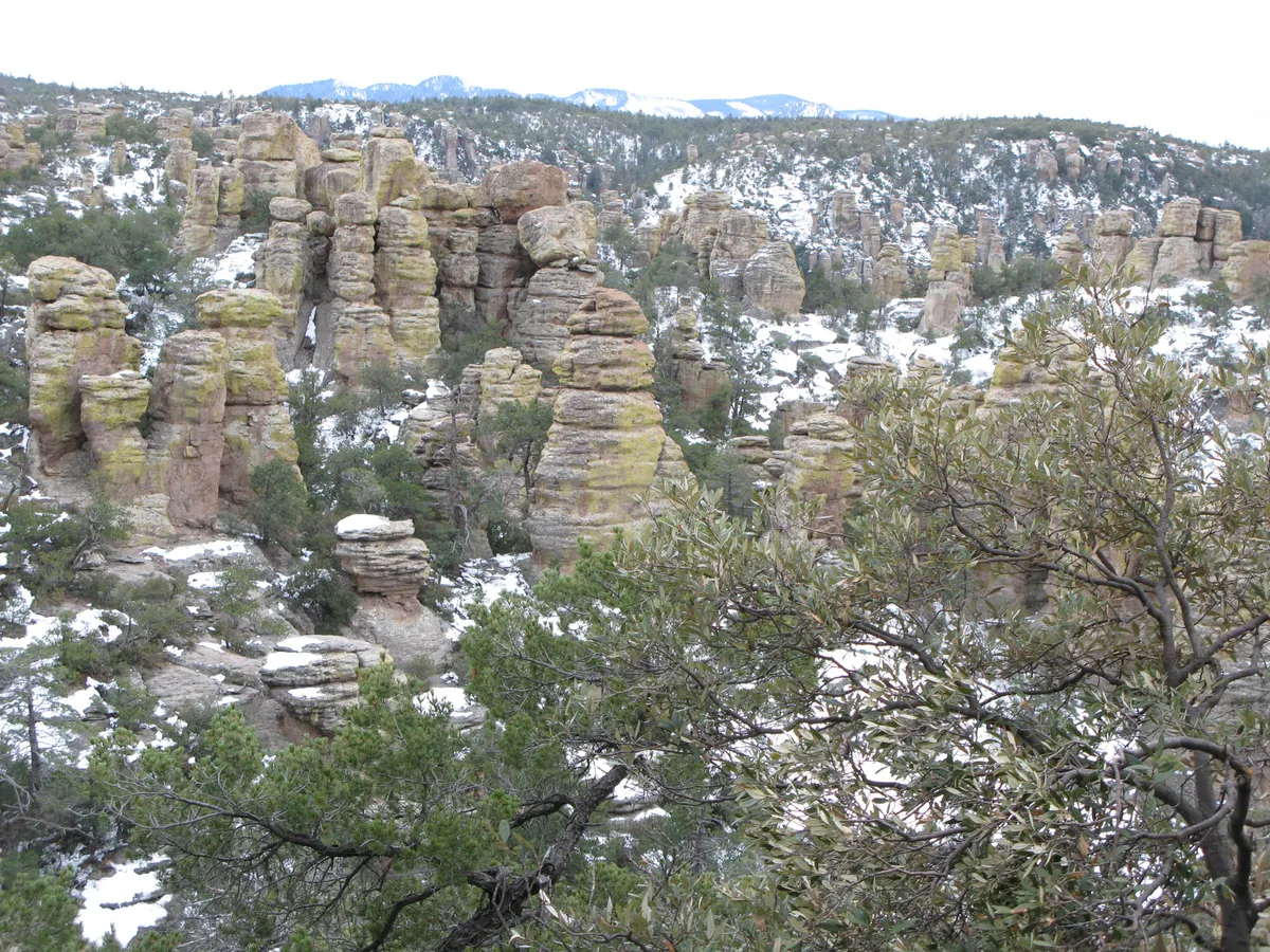
Photo: NPS Photo · Public domain
Chiricahua National Park
Explore rhyolite pinnacles and balanced rocks on foot or by car. Relax at the campground under star-filled, dark skies. See how a mountain range rising between two deserts creates a home for diverse wildlife. Imagine history here. Prehistoric peoples, Apaches, Buffalo Soldiers, Civilian Conservation Corps, ranchers, and homesteaders inhabited Chiricahua.
Entrance Fees
No entrance fee. Other fees may apply for tours, camping, or transportation.
Getting There
Roads and entrances can close temporarily. Check current conditions on nps.gov (opens in a new tab) before you go.
Entrances
- Directions to Chiricahua Visitor Center (opens in a new tab)
Chiricahua Visitor CenterMain
Willcox, AZ · Park road open 24 hours year-round; visitor center 8:30 am–4:30 pm daily
Airports
- TUS
Tucson International Airport · Tucson, AZ
ClosestMajor airport
Distances are approximate road distances; tap a distance for live driving directions.
Towns to stay in
Activities
Top Hikes
3.3 mi · 560 ft gain · loop
Echo Canyon, Hailstone and Ed Riggs trails loop through balanced rocks, the tunnel-like Echo Canyon Grottoes, narrow slots and towering pinnacles. Hike counterclockwise.
Starts at: Echo Canyon Trailhead
7.3 mi · 1,000 ft gain · loop
Via Ed Riggs, Mushroom Rock and Big Balanced Rock trails to the park's most unusual formations, including Pinnacle Balanced Rock and Big Balanced Rock. Lots of rock steps; hike the loop clockwise.
Starts at: Echo Canyon Trailhead
1.8 mi · 500 ft gain · out & back
A short, steep climb to the highest point in the park at 7,310 feet, with 360-degree views and a historic CCC fire lookout on the summit.
Starts at: Sugarloaf Mountain Trailhead
4.8 mi · 1,000 ft gain · out & back
The park's least-used trail climbs through oak and juniper woodland to a ridge, drops into Picket Park and ends at an overlook of a small water-carved bridge across the canyon.
Starts at: Natural Bridge Trailhead
Upcoming Events
9 AM Hiker's Transport (5.7 to 9-mile hike required)
November and December 2026, the 9 am hiker's transport will operate daily. Hikers may ride from Faraway Ranch to the top to hike back down. Departure Times & Locations: 9:00 AM – Faraway Ranch Parking Lot 9:10 AM – Restrooms at Bonita Canyon Campground (Campers Only) Transport Route: from Faraway Ranch to Massai Point or Echo Canyon once daily. Hiking Route: Riders choose between two routes, hiking 5.7 miles or 9 miles back to their vehicle. Trail Conditions & Preparation: These routes descend approximately 1,500 feet in elevation from the upper trailheads to the monument’s lower area. Trails are strenuous, with steep sections, loose sand, and rocky footing. Wear sturdy hiking boots and bring plenty of water, electrolytes, or salty snacks. Important Notes: Service is subject to staff availability Shuttle does not run during inclement weather or dangerous temperatures Limited to the first 13 passengers Groups of 6 or more may be asked to use their own vehicles when space is limited Riders must park in the Faraway Ranch Parking Lot, unless camping overnight Private cars can make the drive at any time. The parking areas may fill during busy winter season, but you are not required to use the transport.
8 AM Weekend Hiker's Transport (5.7 to 9-mile hike required)
November and December 2026, the park will also offer an 8 am shuttle Fridays, Saturdays, and Sundays. Hikers may ride from Faraway Ranch to the top to hike back down. Departure Times & Locations: 8:00 AM – Faraway Ranch Parking Lot 8:10 AM – Restrooms at Bonita Canyon Campground (Campers Only) Transport Route: from Faraway Ranch to Massai Point or Echo Canyon once daily. Hiking Route: Riders choose between two routes, hiking 5.7 miles or 9 miles back to their vehicle. Trail Conditions & Preparation: These routes descend approximately 1,500 feet in elevation from the upper trailheads to the monument’s lower area. Trails are strenuous, with steep sections, loose sand, and rocky footing. Wear sturdy hiking boots and bring plenty of water, electrolytes, or salty snacks. Important Notes: Service is subject to staff availability Shuttle does not run during inclement weather or dangerous temperatures Limited to the first 13 passengers Groups of 6 or more may be asked to use their own vehicles when space is limited Riders must park in the Faraway Ranch Parking Lot, unless camping overnight Private cars can make the drive at any time. The parking areas may fill during busy winter season, but you are not required to use the transport.
Best Time to Visit Chiricahua
Best time to visit: April–May, October–November
The best time to visit Chiricahua National Park is April–May and October–November. Spring and fall bring mild, mostly dry days for the rock trails; summer has 90°F heat and monsoon storms, and winter trails can be icy or snow-packed into March.
In those months, average highs are 65–81°F at Visitor Center. Visitor numbers peak in March, so these months are usually less crowded.
Monthly averages at Visitor Center (5,350 ft). Climate normals (1991–2020): PRISM Group, Oregon State University.
Weather & Climate
The park elevation goes from 5,124 feet at the entrance to 7,310 feet on Sugarloaf Mountain. The top of the park can be 5-10 degrees cooler and windier than the visitor center and entrance. The higher elevations generally have more sun exposure. Clothing layers are always recommended here. The park is often cooler than cities in Arizona with summer highs in the 80s and 90s. Winter lows are often near or below freezing.


